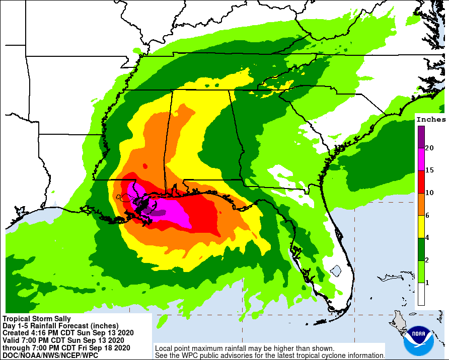
The latest tropical system to impact the Southeast is expected to bring lots of rain to Georgia this week.
Tropical Storm Sally is forecast to become a hurricane by tonight, according to Pam Knox, University of Georgia Cooperative Extension Agricultural Climatologist.
In her blog, Knox said Tropical Storm Sally is bearing down on the Southeast and is expected to become a hurricane by tonight. It is expected to be a Category 2 hurricane when it makes landfall just east of New Orleans sometime on Tuesday. Sally is moving very slowly, which means opportunity for storm surge to develop and for winds to cause damage.
Georgia farmers need to be wary that the major impact from this storm will be rain. In some areas, there is potential for lots of rain. In western and northern Georgia, some areas could receive 4 to 6 inches as the storm slowly wanders and dissipates to our west and then moves back over Georgia as a post-tropical depression later this week.
Everywhere in the state can expect to receive at least 1 to 2 inches over the next five days. The western half of the state does have a chance of seeing some gusty winds, which could start as early as today but are more likely to start on Tuesday. With the saturated soil, that means any wind is more likely to blow over trees, leading to power outages and damage to roofs and buildings.
You can follow updates at the National Hurricane Center at https://www.nhc.noaa.gov/. Don’t focus on the center of the forecast cone. With slow-moving storms, the direction is very uncertain. Rain will spread far out from the center anyway.


